Understanding Environments with the Highest Aircraft Structural Ice Accumulation Rates
Introduction: The Critical Risk of Aircraft Structural Icing
Aircraft structural icing is a significant aviation hazard, affecting flight safety, aircraft performance, and operational decision-making. Rapid ice accumulation on critical surfaces can lead to dramatic increases in drag, severe loss of lift, and dangerous handling qualities. Understanding the exact environments where structural ice is most likely to accumulate at the highest rates empowers pilots, dispatchers, and operators to make informed, safety-first decisions. This guide explores the meteorological, environmental, and operational factors that drive the most rapid ice accretion, offering detailed explanations, real-world examples, and practical strategies for risk mitigation.
The Science Behind Structural Ice Accumulation
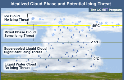
Structural icing forms when supercooled liquid water droplets in visible moisture (such as clouds or precipitation) strike aircraft surfaces at or below 0°C (32°F), freezing on contact. The process is influenced by several key variables:
- Liquid Water Content (LWC): The mass of liquid water per unit volume of air; higher LWC correlates with faster ice accumulation.
- Droplet Size: Larger droplets (often found in cumulus or convective clouds) increase the accretion rate because they contain more water and strike further aft on the airfoil [2] .
- Collection Efficiency (β): The proportion of droplets that actually strike the aircraft surface, influenced by surface shape and airspeed [3] .
- Airspeed: Higher airspeeds result in more droplets impacting the surface per unit time, increasing ice accretion [2] .
- Surface Geometry: Thin, sharply curved surfaces (like propeller blades or wing leading edges) collect more ice than broad, flat surfaces [2] .
These variables combine to make certain environments especially hazardous for rapid ice buildup.
Environments Most Prone to Severe Ice Accumulation
The highest rates of aircraft structural ice accumulation are most likely to occur in environments that combine high liquid water content, large droplet size, and temperatures just below freezing . These conditions are typically found in:
1. Convective Clouds (Cumulus, Towering Cumulus, Cumulonimbus)
Convective clouds contain abundant supercooled liquid water and often feature large droplet sizes. The vertical motion within these clouds promotes the formation of larger droplets and higher LWC, leading to very rapid ice accretion rates. Pilots frequently report severe icing in the tops and active regions of convective clouds, especially in the temperature range of 0°C to -10°C (32°F to 14°F).
Example: Aircraft crossing a cold front or flying through developing thunderstorms may encounter rapid icing that can overwhelm de-icing and anti-icing systems within minutes [4] .
2. Orographically Enhanced Regions (Mountainous Terrain)
Mountains intensify icing hazards by forcing moist air upward, creating thick, supercooled cloud layers with high LWC. The windward sides of mountain ranges are particularly dangerous, as orographically induced updrafts support larger droplets and persistent cloud cover. These areas see more intense icing than low, flat terrain under similar conditions [1] .
Real-World Scenario: Aircraft traversing the windward side of the Rockies or the Alps in winter often encounter continuous, moderate to severe icing, sometimes extending for hundreds of miles.
3. Warm-Front and Frontal Zones
Warm-front regions are characterized by layers of supercooled clouds, often stratus or nimbostratus, with extensive horizontal coverage. When moist air overruns a cold surface, it creates broad swaths of visible moisture at subfreezing temperatures. While droplet size may be smaller compared to convective clouds, the sheer volume and persistence of supercooled water make these areas hazardous for prolonged exposures.
Application: Flights crossing frontal systems, especially in autumn and spring, should be prepared for extended icing encounters and plan alternate routes or altitudes when possible.

Source: oneindia.com
Types of Structural Icing and Their Accumulation Rates
The rate and severity of ice buildup depend on the type of ice forming:
- Clear Ice: Forms at temperatures between 0°C and -10°C in high-LWC, large-droplet environments. It is hard, transparent, and adheres strongly, making it very difficult to remove. This is the most hazardous and fastest-accumulating form [4] .
- Rime Ice: Forms at colder temperatures with smaller droplets, resulting in a brittle, opaque buildup. While it accumulates quickly, it is easier to remove with de-icing boots.
- Mixed Ice: Occurs when both clear and rime ice conditions exist, leading to irregular, rough deposits that severely disrupt airflow and can build up rapidly [4] .
Operational Impact and Risks
Even thin layers of structural ice can have dramatic effects on flight characteristics. According to the Aircraft Owners and Pilots Association, ice accumulations no thicker than coarse sandpaper can reduce lift by 30% and increase drag by 40%. The loss of lift, increased drag, and weight gain can force an aircraft downward or make it impossible to maintain altitude [5] . Severe ice can build so rapidly that pilots have only minutes to escape before control is compromised.
Flight manuals define levels of icing severity, with ‘severe icing’ describing conditions where ice accumulates faster than de-icing systems can handle, requiring immediate action [5] .
Step-by-Step Guidance: Avoiding and Managing Severe Icing Environments
- Pre-Flight Planning: Always check official aviation weather sources (such as the National Weather Service Aviation Weather Center or your country’s meteorological agency) for icing forecasts, SIGMETs, and pilot reports. Use keywords such as “aircraft icing forecast,” “icing PIREPs,” and “freezing level charts.”
- Route Selection: Avoid planned flight through known icing regions, especially convective clouds, frontal zones, or mountainous terrain with active orographic lift. Identify alternate routes or altitudes above or below expected icing layers.
- In-Flight Monitoring: Continuously monitor temperature, visible moisture, and airspeed. Be alert for any signs of ice accumulation, including changes in control feel or performance degradation.
- Immediate Action: If rapid ice begins to accumulate, exit the icing environment as quickly as possible-by changing altitude, turning around, or requesting vectors from air traffic control. Do not rely solely on anti-icing or de-icing systems in severe environments.
- Post-Flight Inspection: After flights in potential icing conditions, conduct a thorough inspection of all critical surfaces and components for residual ice, especially if temperatures remain below freezing.
For more detailed guidance, pilots can consult the FAA’s Aeronautical Information Manual or equivalent authority in their region. Search for “aircraft icing safety” and “severe icing response procedures” for practical checklists and protocols.
Alternative Approaches and Additional Resources
Operators of aircraft not certified for flight into known icing should avoid all visible moisture when temperatures are near or below freezing. For those operating in regions where icing is common, consider equipping aircraft with certified de-icing or anti-icing systems and ensure all crew are trained on their use.

Source: wallpaperaccess.com
If you require specialized advice, you can contact your local aviation weather service office or seek out training courses in aircraft icing avoidance. Many aviation training organizations and flight schools offer weather hazard modules focused on icing, which can be found by searching “aircraft icing training” in your region.
Key Takeaways
The environment with the highest rate of aircraft structural ice accumulation is typically found:
- Within convective or orographically influenced clouds containing large, supercooled droplets and high LWC
- At temperatures between 0°C and -10°C
- On the windward side of mountainous terrain, or in vigorous frontal zones
Understanding and avoiding these environments, combined with diligent pre-flight planning and real-time vigilance, can significantly reduce the risk of encountering severe structural icing. Always use official weather sources and aviation authorities for the most up-to-date hazard information.
References
- [1] NOAA National Weather Service (n.d.). Icing Hazards in Aviation.
- [2] NASA (2024). Introduction to Aircraft Icing.
- [3] Aviation Weather Center (n.d.). How to Properly Use an Icing Forecast.
- [4] The Mobility Forum (2021). Airplane Icing Is No Laughing Matter.
- [5] AOPA (n.d.). Icing: Weather Wise Safety Spotlight.